 November 2006 is laying seige to several records for exteme weather here in Ish River Country. On Tuesday, November 28, the low temperature was 12 degrees, not including the piercing wind chill. The low temp for Wednesday was predicted to be 8 degrees, which would shatter another old record. Seattle also broke the record on Tuesday with 18 degree temps recorded. Whatcom and Skagit counties are the coldest in western Washington, and also have the most snow, and the lingering Arctic air has turned our Fourth Corner in to something akin to Planet Hoth. Whereas points further south have received anywhere from a trace to a couple of inches of snow, my neighborhood had well over a foot on Sunday and the foothills of the North Cascades are reporting two feet of dry, fluffy white stuff.
Even more dramatic is the region's assault on the rain record, a dramatic deluge that even made the Sunday New York Times. Here's their take on our wet, wet month:

"At midday on Sunday, near the end of what is typically Seattle’s rainiest month, the official rain gauge at Seattle-Tacoma International Airport was well past 14 inches and rising, having mocked the November average of about 5.9 inches and smeared the previous single-month record documented at the airport, 12.92 inches, set in January 1953.
Storm after storm has slammed the Puget Sound region, riding warm air from southern parts of the Pacific Ocean.
Now some wonder whether the weather here might deliver the single-month record for rainfall since such data was first collected back in the 19th century. The mark, 15.33 inches, was set in December 1933."
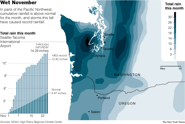 Meanwhile, the Seattle Times reported today that "only a trace of light snow fell overnight so November's precipitation tally at Sea-Tac International Airport stands at 15.26 inches, just shy of the 15.33 inches of rain that made December 1933 the wettest month since weather record-keeping began in the 1890s."
 So, we've got a little over 24 hours for .07 inches of precipitation to fall to set a new high for saturated sogginess here in the Great Northwet. Stay tuned....

The news isn't all harshness: Mount Baker Ski Area has set a new record over the past week for "the most snowfall in one storm cycle in Mt. Baker recorded history," as their website gleefully crows. "We received 8 feet in 5 days and 12 feet of new snow in one storm cycle. This will be a November to remember!" They have plentiful photos of skiers and boarders choking on bottomless, feathery powpow here.

Pacific Northwest
Bellingham
Seattle
Mt. Baker
Winter storm
Rain record
No comments:
Post a Comment